Winter 2010-2011 Weather Discussion

selkirks

Active member
With the meteorological winter of 2009-10 over, it's time to start looking toward Winter 2010-11. Signs are already beginning to emerge regarding the prevailing patterns for next winter. In this thread, I'll lead a discussion of the upcoming winter's weather--from now until April 2011.
The important thing is that information on how to read charts, maps, and other data must be posted in the thread. I'll do my best to stick to this. It's not hard. I have little actual background in meteorology, but it's been a hobby of mine for the last five years or so. If anyone else wants to post reliable information in this thread, it must include information on how to read the charts unless previous posts have included this information.
Information must also come from a reliable source. Wikipedia is not a reliable source. Reliable climate and weather information comes from government agencies and universities. No one else. Commercial sites are okay, but are hit and miss. And they get their info from the government anyway, so why not just go straight to the source?
It's early to start something like this, but... it really isn't. The climate community has been looking at this already for months. It's time for the information to be discussed.
Last thing... Try to keep discussion as national or continental in scope as possible. If you want to discuss regional storms, fine. But make sure that you connect them with what they mean in the grand scheme of things... i.e. the rest of the country. Storms in North America move from West to East, obviously, so a storm discussed early in the week in the Pacific Northwest will eventually make it to the East Coast later in the week.
That's it... First post comes in a few minutes. You'll see what I mean regarding discussion then.
 
DATE... May 1, 2010... 11:00 PM PacificWINTER 2010-11 DISCUSSION
Currently, climatologists are looking at ENSO conditions in the Pacific Ocean. ENSO stands for El Nino/Southern Oscillation. The pattern is a recurring one that has a huge impact on global climate. You know this. The past winter, 2009-10, was a moderate El Nino year.
El Nino conditions mean that sea surface temperatures in the Pacific are warmer than normal. La Nina conditions mean that sea surface temperatures in the Pacific are cooler than normal. Both have equal effect on climate.
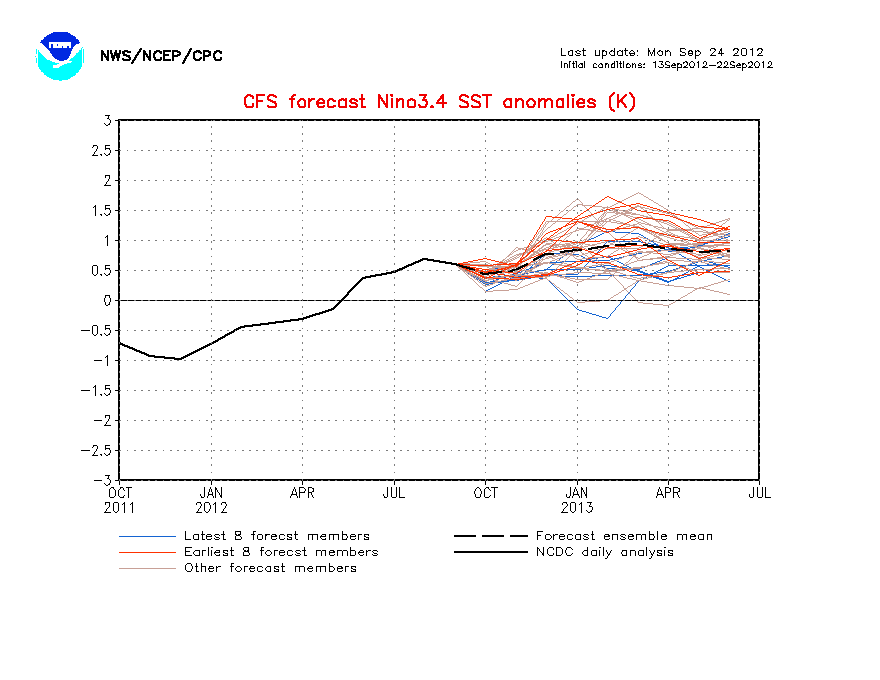
The forecast currently looks for moderate La Nina conditions by next winter. Reliable NOAA (National Oceanic and Atmospheric Administration) models have shown this change for several months now.
Here's the data:
nino34SSTMon.gif

ENSO conditions are measured by a relative scale. The projected January 2011 SSTs (Sea Surface Temperatures) of -1* C make the projected Nina a moderate one. The last Nina was 2008-2009.
But how do we know that we're getting toward the Nina? How do we know that the current El Nino is dropping? By using the Nino 3.4 (a geographic region of the Pacific) anomaly temperatures. See below.
wkxzteq_anm.gif

The object is a GIF. Click on it to see it animated.
As you can see, the temperature anomaly in the Pacific is getting cooler. Make sure you look at the date range at the top to see when the recorded observations were taken.
What does this mean, in two words?Right now, a La Nina for next year seems likely. For the West, that is often excellent for snow--except in more southwestern states, like California. For the East, this is often not too great for snow. But as with all forecasting, climatology is an inexact science. It's also very early.
I look forward to this thread being a source of information and interaction. Here's to hoping for the La Nina to play out. The West needs some snow after last year...
 
IMG fail... click the links to look at the data. It's pretty clear what it says from the language in the post.
 
Here are the missing photos/GIFs. The first one is the Equatorial Temperature Anomaly. Click it to see the animation. The second is the CFS forecast for the La Nina next year.
1272781334wkxzteq_anm.gif
1272781270nino34SSTMon.gif
 
did you consider a thing with this vulcano ? I heard that could really change the climate(at least in Europe). There is so much carbon dioxide in the air and temperature can go like 30-40 degrees higher.
 
The ash partials provides a dimming effect from the sun, leading to colder temperatures = More Snow next year?!?

This may surprise you but in Australia in the even of a major eruption around the world the winters have generally been colder and snowier...

 
hmmm.. if we had a Moderate El Nino last year and the east coast got shit for snow.. then I would think that a Moderate La Nina would mean we would get a decent amount of snow? I guess my logic is incorrect. Either way the east coast gets shafted as usual.
 
El Nino typically is good for the East Coast and California. La Nina is usually good for the Pacific Northwest. But every year is different, because there are more patterns influencing the weather than just ENSO.

Regarding the Iceland eruption, there shouldn't be are huge impact from it. Mt. St. Helens, in comparison, had very little impact on global climate.

And a final note. This is your place to discuss anything related to Winter 2011. Up until Winter there will be very little discussion, but expect weekly ENSO updates. But once winter hits, feel free to discuss individual storms here.
 
its only may can we just enjoy summer and see what happens next winter, weather forecasts are wrong most of the time anyway so im not getting my hopes up for storms 9 months away
 
thats bullshit. New York got less than avg. snowfall this year, when we were forecasted to get above normal. The 08 09 season we got above snowfall when we were forecasted to get below normal.
 
They are constantly getting better. Currently I'm watching more trends in the ENSO than anything. The current El Nino is quickly falling toward a more neutral state. And that's just based on observations. The CFS (the ENSO model forecast above) actually has a relatively good chance of playing out, based on current trends. Maybe not to that extent, but it'll give us some good ideas.

I'll also be watching the PDO (Pacific Decadal Oscillation), the PNA, the AO (Arctic Oscillation), and a whole range of other oscillations and patterns.

Minimal bumps from me until next winter. Just weekly ENSO updates. You don't have to worry about constant reminders about next winter.

And anyone is welcome to join in the discussion, especially if you have more experience than me. Haha
 
where do you live? bc even here in North Carolina we got storm, after storm after storm. It was the second snowiest winter on record. Not only that it was COLD, all the time. Highs in the singles, teens and twentys every day for most of december and january. soo awesome! hope next year can bring the same.
 
Quality thread. I'll certainly be checking in here from time to time, especially once next winter gets rolling. It will be interesting to see how the long range forecasts compare to what actually happens.
 
Not really sure how that particular weather observation makes this the dumbest thread ever. Long range forecasting is generally a good tool for basic climate (i.e. weather patter probability) diagnostics. ENSO has a significant realized and relatively predictable impact on NA winter weather. This won't tell you the specific dates storms will happen, but can help predict the probability that such storms will happen.
 
This thread is foolish, its too difficult for them to forecast a storm accurately within 10 days not to mention a year away. this is useless.
 
If you read and understood what he was saying, it's not about one storm. He is talking general weather trends. For example, if the northwest is going to be cooler and wetter than normal, then it is likely that they are going to get more snow. And if you know this, then this may be the deciding factor in where you are going to take your ski trip this winter.
 
Even so, general trends don't mean shit. Yeah, they can guess the trends but chances are they will be off. And, its not going to affect my skiing next winter regardless cause i go to Plymouth State 20min from Loon and Waterville.
 
General trends definitely have an impact. They determine what is likely to happen through out the season. Now say it's going to be colder and wetter than normal doesn't mean it's going to be 10 degrees and dumping all winter long, but it means that it is likely that there will be more of that than normal. Sure, no weather forecast is a guaranteed by any means, but this stuff definitely has an impact and is relevant information. And when I said "your season" I meant it as a generality as in it may influence some peoples plans. Just don't go hating on a thread because you think because you're not interested in the topic of discussion when in fact it is relevant ski related info that myself and many others have an interest in.
 
Exactly. Thank you. I should have been more clear.

Regardless, just know that this thread is focused on LONG-RANGE and CLIMATOLOGY until about November, when I hope the discussion will shift to more SHORT-RANGE and METEOROLOGY. If you don't understand those terms, look them up.
 
And you got la nina and el nino wrong. La nina gives northern states good amounts and el nino gives southwesterns a lot of snow
 
I should have been more specific, becuase you're basically right. El Nino is good for the MidAtlantic states. Northeast is hit or miss. El Nino is bad for the PNW, good for California. I'll try to throw up a map tomorrow.
 
u guys can discuss weather all you want, one thing is for certain......

little cottonwood canyon will deliver smiles to anyone who enters.
 
UPDATE

We're now looking at -1.0 anomalies in the Nino 3.4 region (a region of the Pacific)! The transition to La Nina has begun... the question is, will it continue? Some forecasts show a spike upward of anomalies in October. But it's still early, and such things often happen when we have such a dramatic killing of the Nino.

So next winter is beginning to look more and more like a (-PDO), (+AMO), and (La Nina). What does this mean? It means that if you live and ski in any of the following states:

British Columbia

Washington

Oregon

Idaho

Western Montana

...you have a good chance for an excellent snow year next winter.

I'll try to post more information soon. I'm having a lot of trouble with the GUI editor and with the HTML editor's problems with photo uploads, I need to see what I can do. We need some HTML5...

 
Well whatever happens it has to be better then 09-10, open 3 weeks late, 8/94 on the last day, and 87cm of natural all season. The east can't get shafted 2 years in a row.
 
well it is currently dumping all over the West right now, near the end of May.
I have already been talking about how the precip and temperature patterns have clearly been changing right in front of our eyes this season. The West has seen consistent snowfall all through April and May.
As far as I can determine, Global Climate Change is in full effect. I predict that the "Winter" season is going to shift, perhaps starting later and lasting longer (kind of like it has this year) Ski resorts may have to adapt soon.... i'm thinking they should open later (like around Xmas instead of around Thanksgiving) and stay open till the end of May!
Non of this is fact based, obviously, i'm simply speculating based on recent events.
 
Climate change is only indirectly involved.

The main thing is that we're seeing an incredible number of ENSO events in a very short time frame. ENSO events normally rotate every 3-8 years. We're seeing an event nearly every year.

2002-03 - El Nino

2003-04 - Neutral

2004-05 - El Nino

2005-06 - Neutral

2006-07 - El Nino

2007-08 - La Nina

2008-09 - La Nina

2009-10 - El Nino

2010-11 - La Nina?

So we've been seeing an extraordinary amount of activity in the Pacific. And we've been seeing a rather unusual number of La Nina events. This could well be caused by climate change. As Earth's atmosphere warms, the general scientific consensus is that there will be more ENSO events, on either side of the spectrum.

As for the length of the season, December to May used to be the standard season. With snowmaking and other technologies, we've been able to move opening day earlier into November. But resorts have a limited operating budget and generally cannot stay open until May. So the season has shifted to November to April. Which in my mind is fair. Why not? It gets resorts more money for capital improvements by getting open for the lucrative Thanksgiving crowds. Though I'd love to see my resort open in May, our weather simply shifts to quickly--we definitely have four seasons in the inland Northwest.
 
Interesting perspective. It was written before this massive El Nino drop however. We're now seeing (-1.0) anomalies in the Nino 3.4 (a region of the Pacific) region. It's looking more and more like Nina. But we'll see...
 
Back
Top