Winter 2010-2011 Weather Discussion

Several interesting developments in the past few weeks.
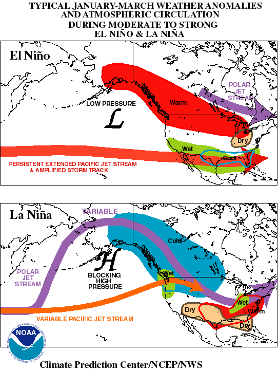
NOAA has issued a La Nina Watch. This is a critical first step. Once NOAA is on-board, you know that this thing is real and more developed. We've known for awhile that this is a budding La Nina, but NOAA is always slow on the uptake. That said, we now have the credibility of the United States' weather services on our side.
Climate Prediction Center is forecasting a cool and wet winter for the PNW. Yes, it's early. But it's not that early, and often the early predictions from NOAA tend to be the closest to fact. Here's an overview and the link.
For the Pacific Northwest:The entire winter period (OND, NDJ, DJF, JFM) looks cooler and wetter than normal. This is typical for La Nina. Who's ready for a great year at Whistler, Baker, Crystal, Bachelor, and Schweitzer?
For the Rest of the Country:The East Coast looks to have equal chances of cooler or warmer than normal temperatures and equal chances of drier or wetter in terms or precipitation. Looks like we'll have to wait and see. Colorado? Follow the link and take a look for yourself. California? Same.
THE LINK: http://www.cpc.noaa.gov/products/predictions/long_range/seasonal.php?lead=5(click on each of the 90-day outlooks)
The cool and wet weather in the PNW lately has excellent implications for the coming winter. Because the West is essentially in a trough of Low Pressure (cool and wet), the northern Pacific is in a ridge of High Pressure. That's good. The calmer and warmer the northern Pacific gets, the more negative the Pacific Decadal Oscillation goes. The stronger the negative PDO, the better the winter (when combined with La Nina) in the PNW. With the PDO already negative and steadily dropping, the current wet and cool weather will likely continue. Deal with it. It means an even more epic season next year.
THE POINT? Pacific Northwest might be the place to be next winter.
More soon.
 
UPDATE: JULY 20, 2010 @ 11:47 PM

Our La Nina is progressing nicely. Our -PDO (negative Pacific Decadal Oscillation) is progressing nicely. The combination of the two could mean a potent combination for the Pacific Northwest. It's still early, but we are getting some signals and analogs (years that meteorologists and climatologists use to compare to this year) are being compiled as we speak. I'm stoked to see this potentially coming to fruition. But don't hold your breath. The La Nina could still fade by winter (...or it could strengthen, which could also be bad for the PNW--weak to moderate La Nina years are best for that region).

This is a very basic overview of what a La Nina would mean for the United States.

208053main_lanina_HI.jpg


This is a very general view. Note that areas of forest green are "equal chances." That means that in La Nina winters, it is essentially a 50-50 shot of either warm or cool temperatures and little or a lot of precipitation.

El-Nino-La-Nina-effects.gif


This is also a very general view which compares La Nina (Winter 2011-expected) and El Nino (Winter 2010-previous).

However, this year is different from most. We had a moderate-strong El Nino in Winter 2010. In Winter 2011, we are expected to have a moderate La Nina. Rules change for El Nino-to-La Nina transition winters.
 
The Mammoth Forums are exceptional for weather and climate information. They've got some great amateur and professional forecasters in there.

That said, we're still looking at La Nina and a -PDO. That means we'll probably be seeing cold in the western 1/3 of the country and a blowtorch (warm) for the eastern 2/3 of the country. At least that's the talk right now based on analogs and patterns.
 
Our La Nina is still progressing nicely. A strong -PDO signature is building in the Northern Pacific. And a large pool of arctic air is building over far northern Canada.

What does this mean?

The La Nina and the -PDO will contribute in bringing cool, moist air to the Pacific Northwest. The pool of arctic air, when streaming southward, will enhance cool temperatures. The collision of the cool and moist air in the Pacific Northwest and the Northern Plains usually causes an abundance of powder. Dry powder. In high amounts.

Stay tuned throughout the next few weeks as I'll begin to take a look at snowmaking favorability for Loveland and Arapahoe Basin. I'll also work on tracking any possible early-season storms. Last year a strong storm brought 25" to Grand Targhee in early October. Will we see a repeat this year? Will first tracks be had early in October, or late in September? Stay tuned.
 
UPDATE on SNOWMAKING PROSPECTS

It's really early right now, but it looks like the official start of snowmaking at Loveland, Colorado may have to be delayed due to warm temperatures. Highs in the upper-40s and lows in the mid-30s are simply too warm for effective snowmaking. We'll see; it's still very early, but right now it's looking like a brief delay to the start of snowmaking operations.
 
definetly threads; the talk here (PA) is saying that its going to b a mild winter. Not sure if that's correct or not, because that might just be people comparing it to this last winter, in which we got pounded, and had several pow days (which is pretty unusual).
 
Most likely, there's some truth in that statement. The middle Atlantic states tend to lose in La Nina winters. But there are odd exceptions where an above average winter is possible. I'd say slightly below average for much of Pennsylvania.
 
Awesome info, I took a peak at some of those maps on NOAA as well, looks like Oregon/Washington/BC will be the place to be this winter. I'm anxious to see what Colorado and Utah will be like since I will be spending hopefully 2 weeks out there early season, and 1 week in the prime season.
 
UPDATE: September 19, 2010 at 12:30 PM

It's beginning to look as if snowmaking operations in Colorado may have to be delayed for at least a week as warm temperatures, high winds, and low humidity continues aloft. This pattern is supposed to be broken by a cold front on Tuesday, but unfortunately, that will likely not bring temperatures down enough for a viable start to snowmaking.

Attached is the official NWS forecast for Loveland, Colorado.

This Afternoon: Sunny, with a high near 64. West wind around 11 mph.

Tonight: Mostly clear, with a low around 42. West wind between 10 and 14 mph, with gusts as high as 22 mph.

Sunday: Sunny, with a high near 66. West wind between 6 and 11 mph, with gusts as high as 18 mph.

Sunday Night: Mostly clear, with a low around 39. West southwest wind between 6 and 13 mph.

Monday: A 20 percent chance of showers and thunderstorms after noon. Mostly sunny, with a high near 61. Breezy, with a west southwest wind between 14 and 20 mph, with gusts as high as 31 mph.

Monday Night: A 20 percent chance of showers and thunderstorms before midnight. Partly cloudy, with a low around 36.

Tuesday: Mostly sunny, with a high near 57.

Tuesday Night: Partly cloudy, with a low around 34.

Wednesday: Mostly sunny, with a high near 56.

Wednesday Night: Partly cloudy, with a low around 36.

Thursday: Mostly sunny, with a high near 57.

Thursday Night: Partly cloudy, with a low around 35.

Friday: Mostly sunny, with a high near 58.

 
Generally the West scores in La Nina years. But exceptions do occur, and Colorado has been known to see slightly drier winters during La Nina years. For what it's worth, however, the National Weather Service is forecasting an average winter for both Colorado and Utah.

2007-08 was a La Nina year, for an example, albeit a weak-moderate one. This one will almost undoubtedly be a strong one.
 
To be honest, there are few situations where Utah can't win. There doesn't seem to be a strong correlation between La Nina or El Nino and cold/wet winters. La Ninas just tend to be slightly better and El Ninos slightly worse because that is also the trend across the entire West.
 
To whoever up there that said the volcano was going to affect the global climate consider this; the 2010 iceland volcano eruption was the first EVER carbon neutral eruption due to the emissions saved from all the planes being grounded. The amount of carbon that went in the air from that is NOTHING compared to what we put out every day.

And to the OP, thanks for all the work, gets me stoked to ski this season as I live in Vancouver. Are you a meteorologist in training or something?
 
The ridge of High Pressure is still in place over the West, although signs are emerging that point to an end to this pattern. The PNW was broken out of this ridge today and should see seasonable conditions through this week, with very wet conditions possible by this weekend.

In Colorado, snowmaking prospects are looking much better than they were, but still nowhere where they should be for this time of year. Lows are still forecasted to stay slightly above freezing for the mountain passes near Loveland and Arapahoe Basin. Expect a return to normal conditions by Thursday and Friday. That's when I expect snowmaking conditions to be most favorable. If the trend toward cooler temperatures continues and they do not warm too much during the day, then Loveland/A-Basin openings during the week of 10/10-10/16 do not seem out of the realm of possibility. That is just preliminary information from the National Weather Service. I'm not looking at models at this time.

Bear in mind that this is a forecast. That means that conditions can and will change.
 
52 degrees and cloudy here in Delaware, I could see my breath when I went to chem class this morning. I probably looked stupid breathing hard out of my mouth to make sure that's what I was seeing, but so worth it. Don't have much else to contribute at this point other than I'm stoked. Now if only the streets would dry so I could skate to class instead of walking.
 
i was doin the same thing walking to class and i know ppl were staring at me ... pretty fkin cold in ny/nj right now.
 
If only that were true. I can assure you that in 2004-05, the PNW most certainly was not the place to be. Most of our resorts opened in December and closed for the season in late February. But I shall speak no longer of that accursed year.
 
Hey guys, how does Japan look for this winter? And what I'm hearing is that this winter will be above average like 96', and next winter will be fucking epic? is that how it's working out?cheers
 
what does all this mean for new england? we have already had a storm that delivered significant snow to upper elevations which is unusual for this time of year.
 
Bump. The first of many Pacific storms is making it's way right now into the PNW. Some pretty incredible snow totals are possible in the Cascades for October. Lots of snow is also forecasted to fall in Northern Idaho, Western Montana, Utah, and Colorado. Winter Storm Watches and Warnings are currently in effect.

Snowbird: 20-30" through Tuesday.

Timberline: 30-50" through Tuesday (seriously).

Schweitzer: 11-20" through Tuesday.

Lookout: 11-20" through Tuesday.

That's just a small sampling. Totals could increase or decrease obviously as this event unfolds. But the active weather continues throughout the long term forecast. Cool, wet, snow in the mountains for the PNW--generally typical mid-November conditions.

I'm tweeting this event live using my username @skinorthwest and the hashtag #PNWstorm. Major event--we'll see how it plays out. For now, stay posted on Twitter and right here.
 
In seven of the nine La Nina seasons recorded since 1970, Sunshine(NW) has enjoyed snowfalls above its annual average, according to Sunshine's own records. This year, Alberta's favourite ski and snowboard resort is preparing for another epic season in which this system blesses the resort with a surplus of Sunshine's world famous champagne powder.

Even better: Although La Nina years are supposed to bring frigid northern air, for reasons that climatologists don't quite understand, three of the last five La Nina winters since 1995 have been warmer than average, Environment Canada reports.

And Snow-Forecast.com adds: "Early indications are promising that we will generally have another great ski season." The La Nina weather pattern, it adds, "is very good news" for western Canada.

More snow and milder temperatures make your time on the slopes even more memorable.

Stooooked!
 
Mild temps are not the expectation in the PNW for this winter, however. We're expecting cold, wet weather; some predictions are for a winter like we haven't seen since the 1950s.
 
Back
Top