Input for my Backcountry Hiking project

Hi everyone, a bit different post than I normally do on Newschoolers, but I know a lot of members in here also do a lot of hiking and stuff in the off season so I figured it was worth a shot. I am a member of a 5 student team of hikers from Worcester Polytechnic Institute working on a research project to create a web-app that simplifies and streamlines the process of planning a backpacking trip (just to be clear, unfortunately not backcountry skiing). If some of you have just a few minutes to fill out our anonymous survey our group would greatly appreciate it! We are having trouble getting enough data working remotely due to COVID.

http://wpi.qualtrics.com/jfe/form/SV_8c9GzTqbyRxNZcx

This is a completely anonymous, non-commercial survey for academic purposes only. If anyone has any questions please feel free to comment them here or message me or any of the contacts provided on the survey page.
 
14174419:Tnski said:
No but a gps/topo type app that shows were your at at all times on a topo map would be killer

Agreed that would be so sick! It may be too difficult for us to manage with only 4 more weeks and only a few of us being good at the coding stuff, but may get passed on to a future project for another group of students. Thanks for the input!
 
I have a significant amount of backcountry hiking experience. While in the contiguous US I primarily use Gaia. When abroad I may use other GPS apps. Gaia (Premium version) does everything I could possibly want. I do often carry paper maps and a compass when on significantly longer trips.

It sounds like this project is trying to re-invent what is already out there in many, many apps. Still, I wish you the best and I answered your survey.
 
14174525:iFlip said:
I have a significant amount of backcountry hiking experience. While in the contiguous US I primarily use Gaia. When abroad I may use other GPS apps. Gaia (Premium version) does everything I could possibly want. I do often carry paper maps and a compass when on significantly longer trips.

It sounds like this project is trying to re-invent what is already out there in many, many apps. Still, I wish you the best and I answered your survey.

That app is pretty decent, its got a compass and 40' conture lines. Does it show were you are using the phones GPS when there's no cell service? I'm hooked so far, nice tip.
 
14174525:iFlip said:
I have a significant amount of backcountry hiking experience. While in the contiguous US I primarily use Gaia. When abroad I may use other GPS apps. Gaia (Premium version) does everything I could possibly want. I do often carry paper maps and a compass when on significantly longer trips.

It sounds like this project is trying to re-invent what is already out there in many, many apps. Still, I wish you the best and I answered your survey.

yeah we have done a lot of research/use of Gaia, it works wonderfully in the United States. The goal has become more orientated to planning a trip and creating a constant feedback of post hike-information, (rather than make another map/gps trip execution app like you said) especially because in places like Glacier National Park it becomes a pretty convoluted process with all the permitting applications and rules and trail statuses.

Thank you for your feedback and taking the survey!
 
14174419:Tnski said:
No but a gps/topo type app that shows were your at at all times on a topo map would be killer

Check this out: https://play.google.com/store/apps/details?id=com.vecturagames.android.app.gpxviewer.pro

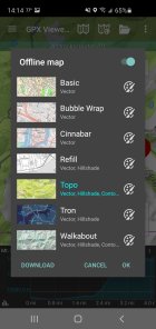
I downloaded their free version cuz most/all of the 13/14ers in CO have gpx routes and then this year I paid like $5-10 I think for the upgraded pro version. You can download maps to be used offline. Works pretty well and doesn't drain your battery. Very accurate on my phone.
 
14174525:iFlip said:
I have a significant amount of backcountry hiking experience. While in the contiguous US I primarily use Gaia. When abroad I may use other GPS apps. Gaia (Premium version) does everything I could possibly want. I do often carry paper maps and a compass when on significantly longer trips.

It sounds like this project is trying to re-invent what is already out there in many, many apps. Still, I wish you the best and I answered your survey.

glad this was said, i was going to say things like Gaia and caltopo already exists.
 
14174625:Trumpkin2020 said:
Check this out: https://play.google.com/store/apps/details?id=com.vecturagames.android.app.gpxviewer.pro

I downloaded their free version cuz most/all of the 13/14ers in CO have gpx routes and then this year I paid like $5-10 I think for the upgraded pro version. You can download maps to be used offline. Works pretty well and doesn't drain your battery. Very accurate on my phone.

It's 5.50$ ti download? Hiw does this work were there's no cell service, the phones GPS and downloaded maps? And will this work to show my routes in places that have no previous routes and will my secret routes be visible to everyone? I don't mind paying just some insight would be greatly appreciated. Thanks in advance.
 
14174633:Tnski said:
It's 5.50$ ti download? Hiw does this work were there's no cell service, the phones GPS and downloaded maps? And will this work to show my routes in places that have no previous routes and will my secret routes be visible to everyone? I don't mind paying just some insight would be greatly appreciated. Thanks in advance.

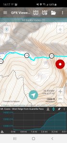
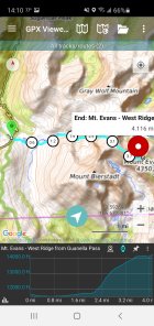
Yeah you download the maps and your phone GPS works anywhere. You can only get gpx routes if you personally map them yourself (either drawing or physically traveling it) or if you download someone's route from the internet. If there are no previous routes you will have to create one. Pretty sure you can draw one on a computer and download it to the app (here? https://trackbook.online/) . Your routes are private unless shared. Here's a screenshot of what it looks like on a route I downloaded.

973200.jpeg

973202.jpeg

973203.jpeg
 
14174533:Tnski said:
That app is pretty decent, its got a compass and 40' conture lines. Does it show were you are using the phones GPS when there's no cell service? I'm hooked so far, nice tip.

Yes, just download the area maps ahead of time and it works as well offline as online. Any waypoints or tracks you make while you’re out there will sync once you’re back online. And it all syncs between computer and phone.
 
14174603:peterspringer10 said:
yeah we have done a lot of research/use of Gaia, it works wonderfully in the United States. The goal has become more orientated to planning a trip and creating a constant feedback of post hike-information, (rather than make another map/gps trip execution app like you said) especially because in places like Glacier National Park it becomes a pretty convoluted process with all the permitting applications and rules and trail statuses.

Thank you for your feedback and taking the survey!

When I led an international expedition I used Avenza.

A constant feedback of post-hike information? You mean exactly what AllTrails already does?
 
14174776:iFlip said:
When I led an international expedition I used Avenza.

A constant feedback of post-hike information? You mean exactly what AllTrails already does?

Yes, a similar concept except in addition to feedback for others planning hikes, it will ideally have a post-hike survey aspect that will get automatically routed to the corresponding ranger that oversees that region, where they can then take action if needed. Our project is being designed specific to Glacier National Park, but could be applied to many others.
 
Back
Top