Does your park crew have to record features?

Dstan

Member
I'm trying to do some research for my app, but I've never worked park crew so I could use some help from people that have.

Some people on park crews have told me that they enter their setups into software like 1Risk or 1Park. Others have said that all they have to do is initial a clipboard when they do a rake lap. I’ve also seen park crew take a bunch of measurements of jumps after someone gets injured.

My question is- What's the norm? What does your park do? And more specifically, what information gets recorded and why? Is it for insurance/liability purposes or planning purposes? Does just the presence of features get recorded or certain measurements?
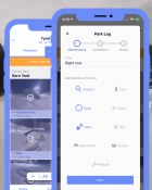
 
I think across the board most resorts do the same things, but use different softwares or variations of paper charts. Where I work (and I assume at all the Boyne Resorts its the same) we use 1Risk to keep records. Every park has to have an up to date feature map showing the relative placement of all the features, and all the features on the hill are listed and classified as either XS, S, M, L (these sizes determine which sign we put at the top). Then on a daily basis either the manager or one of us diggers will fill out the park log, checking off features as Open, Raked, Groomed, Shoveled, Salted, Painted/Marked, Opening committee (I'll get to that in a bit) etc.

Edit: Groomers also have their own log, haven't used that one much but I think it has to do with the fact that we can't open a park unless it was groomed the night before

Rail features generally aren't measured, but jumps however I believe we take measurements on the day they are first opened. To open the park after a rebuild we have "Opening Committee" where the park manager or a senior digger skis through with the head of patrol and the head of mountain ops to make sure it meets managements expectations of safety/quality.

If a rail or jump has a serious accident or a lot of small ones it will get closed, have measurements recorded on that day, and opening committee will discuss how to change the feature or whether to take it out entirely.

Might have missed some stuff but yeah we log stuff pretty much only for liability, park planning happens on anything from bar napkins to Sketchup.

**This post was edited on Oct 21st 2019 at 10:40:20am
 
14068372:a_burger said:
I think across the board most resorts do the same things, but use different softwares or variations of paper charts. Where I work (and I assume at all the Boyne Resorts its the same) we use 1Risk to keep records. Every park has to have an up to date feature map showing the relative placement of all the features, and all the features on the hill are listed and classified as either XS, S, M, L (these sizes determine which sign we put at the top). Then on a daily basis either the manager or one of us diggers will fill out the park log, checking off features as Open, Raked, Groomed, Shoveled, Salted, Painted/Marked, Opening committee (I'll get to that in a bit) etc.

Edit: Groomers also have their own log, haven't used that one much but I think it has to do with the fact that we can't open a park unless it was groomed the night before

Rail features generally aren't measured, but jumps however I believe we take measurements on the day they are first opened. To open the park after a rebuild we have "Opening Committee" where the park manager or a senior digger skis through with the head of patrol and the head of mountain ops to make sure it meets managements expectations of safety/quality.

If a rail or jump has a serious accident or a lot of small ones it will get closed, have measurements recorded on that day, and opening committee will discuss how to change the feature or whether to take it out entirely.

Might have missed some stuff but yeah we log stuff pretty much only for liability, park planning happens on anything from bar napkins to Sketchup.

**This post was edited on Oct 21st 2019 at 10:40:20am

Thank you so much. That’s hugely helpful!

What’s your experience generally with 1risk- is it nice to use?
 
14068379:Dstan said:
Thank you so much. That’s hugely helpful!

What’s your experience generally with 1risk- is it nice to use?

Infinitely better then using the paper forms, which is the only other thing I have experience with. For the daily logs you basically just have a spreadsheet for each park and can check off entire columns at once, or get more specific. With the park maps your just dropping pins on google maps, and the feature list is also pretty simple. .
 
14068400:CalumSKI said:
my park crew makes a jump and hope it works , no math involved so i dont think they do this tbh

It’s kind of scary how prevalent that still is, the industry should be pushing responsible park design to smaller independent operators a lot harder. The big lawsuit that ends park skiing as we know it everyone is afraid of won’t happen at a big resort, it will be some small hill with volunteers who have good intentions but not the resources and info they need.

Like idk why NSAA hasn’t made a free guidebook or something to distribute with Best Practices, they seem way more keen on pushing PEEPs and SMARTstyle which while important don’t really get to the root of what most lawsuits seem to target (bad park design and operator negligence)
 
14068484:ConesForBreakfas said:
Any tips on dimensioning for backcountry jumps?

Make sure your jump is taller than you are. Then do the math.

Too bad Whitewaters jumps are all under 20 feet, completely unmaintained and built by volunteer snowboarders. That means no lips table tops beside the bunny hill. *deep breath, sigh*
 
a_burger covered the majority of it....

I work for a park crew that manually logs their builds, maintenance, incidents and feature inventory.

Before a park ever gets opened, we also have a detailed map of features that includes a depiction, size, and name of each feature. We number the features on the map to the corresponding feature name on a list. This is helpful for locating incidents on hill. Rather than trying to tell patrol that a rider is down near the "DFD", you can just give them a feature number, they can look at the map and know where the injury occurred.

Along with our feature map, with names and descriptions, we have a daily Park Opening sign off sheet. A member of park crew will sign off on whether or not the trail has been groomed, if features are properly suited for opening (groomed lips, features packed in, features in proper riding condition, etc.) These logs are kept in our Park Crew office and scans are sent over to our Risk department.

If any injury occurs on a feature, we may or may not close the feature for inspection. This will usually happen if the rider claims that their fall was because of the feature (loosely in the snow or gashes causing a snag) or if there are a large number of injuries in relation to one specific feature.

If jumps are being measured following an injury, I can only assume that they are taking measurements to make sure that the jump falls within the size parameters stated on signage at the top of the park that it is in. If someone is hurt on a jump that is considered "Large" and it is located within a "Medium" park, that could cause a huge stink in the realm of liability.

Hope this helps....
 
topic:Dstan said:
I'm trying to do some research for my app, but I've never worked park crew so I could use some help from people that have.

Some people on park crews have told me that they enter their setups into software like 1Risk or 1Park. Others have said that all they have to do is initial a clipboard when they do a rake lap. I’ve also seen park crew take a bunch of measurements of jumps after someone gets injured.

My question is- What's the norm? What does your park do? And more specifically, what information gets recorded and why? Is it for insurance/liability purposes or planning purposes? Does just the presence of features get recorded or certain measurements?

What kind of app is it?
 
14068539:11matby said:
a_burger covered the majority of it....

I work for a park crew that manually logs their builds, maintenance, incidents and feature inventory.

Before a park ever gets opened, we also have a detailed map of features that includes a depiction, size, and name of each feature. We number the features on the map to the corresponding feature name on a list. This is helpful for locating incidents on hill. Rather than trying to tell patrol that a rider is down near the "DFD", you can just give them a feature number, they can look at the map and know where the injury occurred.

Along with our feature map, with names and descriptions, we have a daily Park Opening sign off sheet. A member of park crew will sign off on whether or not the trail has been groomed, if features are properly suited for opening (groomed lips, features packed in, features in proper riding condition, etc.) These logs are kept in our Park Crew office and scans are sent over to our Risk department.

If any injury occurs on a feature, we may or may not close the feature for inspection. This will usually happen if the rider claims that their fall was because of the feature (loosely in the snow or gashes causing a snag) or if there are a large number of injuries in relation to one specific feature.

If jumps are being measured following an injury, I can only assume that they are taking measurements to make sure that the jump falls within the size parameters stated on signage at the top of the park that it is in. If someone is hurt on a jump that is considered "Large" and it is located within a "Medium" park, that could cause a huge stink in the realm of liability.

Hope this helps....

Thanks, man. This is awesome!

So do you give a copy of that map to each patroller each day? Or do they get just one copy and they direct each other over radio?
 
yeah my mountain throws it in and sees how it works for the day, if kids keep gettin merked it wont be there the next day. if it works, well it works.
 
14068618:T.L. said:
What kind of app is it?

ullr.ski - you can check it out here. It’s a park report app. My project right now is to make it more useful for park crews and ski areas

**This post was edited on Oct 22nd 2019 at 10:18:29am
 
14068689:Dstan said:
Thanks, man. This is awesome!

So do you give a copy of that map to each patroller each day? Or do they get just one copy and they direct each other over radio?

The copy makes its way to the main patrol office and is accessible by all patrollers if needed.

Radio comms usually take care of everything, but the map and info is there as a backup guide and for liability purposes.
 
14068474:a_burger said:
It’s kind of scary how prevalent that still is, the industry should be pushing responsible park design to smaller independent operators a lot harder. The big lawsuit that ends park skiing as we know it everyone is afraid of won’t happen at a big resort, it will be some small hill with volunteers who have good intentions but not the resources and info they need.

Like idk why NSAA hasn’t made a free guidebook or something to distribute with Best Practices, they seem way more keen on pushing PEEPs and SMARTstyle which while important don’t really get to the root of what most lawsuits seem to target (bad park design and operator negligence)

To be fair, the park that CalumSKI is talking about doesn't build jumps large enough for any massively serious accidents to happen. The jump is never large enough where casing will wreck you, maybe bruise a heel at worse (unless you mess up a trick obviously) and overshooting isn't really an option on the run it's on. If there was a serious accident it would entirely be human error. Either someone gets plowed into on the landing or someone messes up hard on a trick. Either way, barring a total freak accident, I wouldn't expect more than broken bones and concussions which can and do happen anywhere on the mountain.
 
If anyone is still interested in this, I built a way to log park maintenance and I spec ruins in Ullr and just launched it. Let me know if you want to check it out!

957973.png
 
Back
Top